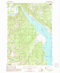
1988 Map of Hebgen Dam
USGS Topo · Published 1989About this map
The Hebgen Dam controls the upper flow of the Madison River in this 1980s landscape, which is defined by the legacy of dramatic geologic change. North of the dam lies Earthquake Lake, a permanent reminder of the seismic shifts that reshaped this drainage. The area within the Gallatin National Forest serves primarily as a recreational and conservation corridor, illustrated by several public facilities such as the Spring Creek Campground and Rumbaugh Campground situated along the shores of Hebgen Lake.
Find a feature on this map
30 named features on this map. Tap any name to fly to it.
Don’t see what you’re looking for? This feature index may not catch every label — zoom into the map to look around manually.
Map Details
Editions of this 1988 Hebgen Dam Map
This is the sole edition of this map. No revisions or reprints were ever made.
Other maps of this area

1950 · Hebgen Dam
USGS Topo · 1:62,500

1955 · Ashton
USGS Topo · 1:250,000

1958 · Ashton
USGS Topo · 1:250,000

1958 · West Yellowstone
USGS Topo · 1:62,500
1958 · Tepee Creek
USGS Topo · 1:62,500

1960 · Ashton
USGS Topo · 1:250,000

1964 · Targhee Pass
USGS Topo · 1:24,000

1964 · Targhee Peak
USGS Topo · 1:24,000

1964 · Henrys Lake
USGS Topo · 1:62,500
1986 · Madison Arm
USGS Topo · 1:24,000