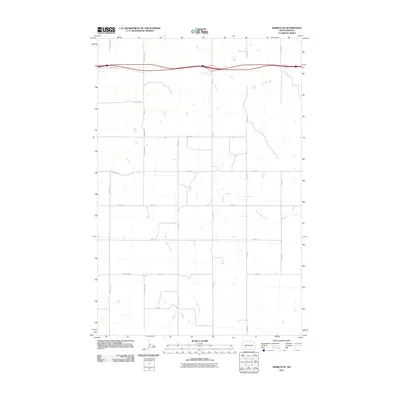
2011 Map of Hebron SE
USGS Topo · Published 2011About this map
Beaver Creek and Heart Butte Creek define the drainage patterns of this rural Stark County landscape, where the agricultural grid meets the path of Interstate 94. The map illustrates a high-plains environment organized by a precise network of section-line roads, including 79th Ave SW and 76th Ave, which serve the dispersed farmsteads characteristic of the region. The convergence of these watercourses toward the southeast suggests the rolling nature of the terrain between the Heart and Knife River watersheds. This 2011 survey captures the area during a period of modern infrastructure, showing the relationship between the high-speed transit of the interstate corridor and the secondary local routes like 38th St SW and 45th St that form the backbone of the local farming economy.
Find a feature on this map
20 named features on this map. Tap any name to fly to it.
Don’t see what you’re looking for? This feature index may not catch every label — zoom into the map to look around manually.
Map Details
Editions of this 2011 Hebron SE Map
This is the sole edition of this map. No revisions or reprints were ever made.
Other maps of this area

1938 · Heart Butte
USGS Topo · 1:48,000

1944 · Heart Butte
USGS Topo · 1:62,500

1953 · Dickinson
USGS Topo · 1:250,000

1954 · Bismarck
USGS Topo · 1:250,000

1957 · Dickinson
USGS Topo · 1:250,000

1958 · Bismarck
USGS Topo · 1:250,000

1960 · Clark Butte NW
USGS Topo · 1:24,000

1960 · Heart Butte NW
USGS Topo · 1:24,000

1960 · Clark Butte NE
USGS Topo · 1:24,000
1970 · Glen Ullin NW
USGS Topo · 1:24,000