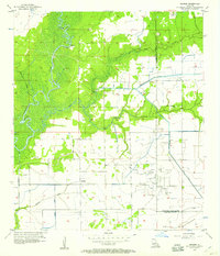
1956 Map of Hecker
USGS Topo · Published 1957About this map
The Calcasieu River defines the western edge of this coastal prairie landscape, winding past Point Fine and Stackpole Island near the small settlement of Hecker. In the mid-1950s, this area was a hub of resource extraction and agriculture, dominated by the sprawling infrastructure of the Iowa Oil and Gas Field. Dozens of Oil Wells and Gas Wells are scattered across the southern sections, while an extensive network of artificial waterways, including the Louisiana Irrigation Canal and Jones Canal, supported the local rice farming economy.
Find a feature on this map
26 named features on this map. Tap any name to fly to it.
Don’t see what you’re looking for? This feature index may not catch every label — zoom into the map to look around manually.
Map Details
Editions of this 1956 Hecker Map
3 editions found
Other maps of this area

1932 · Lake Charles NE
USGS Topo · 1:31,680

1932 · Lake Charles NW
USGS Topo · 1:31,680

1935 · Moss Bluff
USGS Topo · 1:31,680

1935 · Gaytine
USGS Topo · 1:31,680

1942 · Lake Charles
USGS Topo · 1:62,500

1946 · Lacassine
USGS Topo · 1:31,680

1947 · Gaytine
USGS Topo · 1:31,680

1947 · Fenton
USGS Topo · 1:31,680

1947 · Moss Bluff
USGS Topo · 1:31,680

1947 · Hecker
USGS Topo · 1:31,680