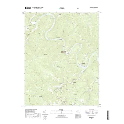
2019 Map of Heidelberg
USGS Topo · Published 2019About this map
The Kentucky River carves a dramatic, winding path through this portion of the Daniel Boone National Forest, defining the boundaries of Lee Co and neighboring Estill Co. Small river settlements and hamlets like Heidelberg, Willow Shoals, and Yellow Rock dot the riparian corridor, connected by the rugged topography of Spencer Ridge and Hale Ridge. This landscape is characterized by its high density of family and community burial grounds, such as Watson Cem, Kell Cem, and the Beatty Place Cem, providing a detailed record for genealogical research in this Appalachian region. The mapping of the Shel Towee Trace and the Hogge Ridge Sheltowee Trace NRT highlights the area's significance for regional transit and recreation, while names like Stone Coal Cem hint at the historical extractive industries that once supported local communities like Ida May and Delvinta.
Find a feature on this map
71 named features on this map. Tap any name to fly to it.
Don’t see what you’re looking for? This feature index may not catch every label — zoom into the map to look around manually.
Map Details
Editions of this 2019 Heidelberg Map
This is the sole edition of this map. No revisions or reprints were ever made.
Other maps of this area

1891 · Manchester
USGS Topo · 1:125,000

1892 · Beattyville
USGS Topo · 1:125,000

1952 · Leighton
USGS Topo · 1:24,000

1952 · Beattyville
USGS Topo · 1:24,000

1952 · Cobhill
USGS Topo · 1:24,000

1952 · Heidelberg
USGS Topo · 1:24,000

1952 · Irvine
USGS Topo · 1:24,000

1953 · Mc Kee
USGS Topo · 1:24,000

1953 · Booneville
USGS Topo · 1:24,000

1953 · Sturgeon
USGS Topo · 1:24,000