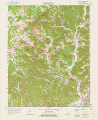
1974 Map of Heidrick
USGS Topo · Published 1975About this map
Louisville and Nashville rail lines dominate the valley floors of this Knox County landscape in the mid-1970s, connecting industrial and residential hubs like Rossland, Arkle, and Heidrick. The terrain is defined by a dense network of steep ridges and hollows, where extensive extractive activity is evident through numerous Strip Mine sites and clusters of Gas Well pads scattered across the uplands. Significant local landmarks such as the Gilliam Knob Lookout Tower and Scott Chapel (Cem) reflect the area's mix of resource management and long-standing community roots.
Find a feature on this map
84 named features on this map. Tap any name to fly to it.
Don’t see what you’re looking for? This feature index may not catch every label — zoom into the map to look around manually.
Map Details
Editions of this 1974 Heidrick Map
2 editions found
Other maps of this area

1886 · Cumberland Gap
USGS Topo · 1:125,000

1888 · Cumberland Gap
USGS Topo · 1:125,000

1890 · Williamsburg
USGS Topo · 1:125,000

1891 · Manchester
USGS Topo · 1:125,000

1891 · Cumberland Gap
USGS Topo · 1:125,000

1893 · London
USGS Topo · 1:125,000

1894 · Williamsburg
USGS Topo · 1:125,000

1897 · London
USGS Topo · 1:125,000

1952 · Corbin
USGS Topo · 1:24,000

1952 · Barbourville
USGS Topo · 1:24,000