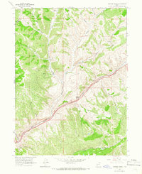
1964 Map of Heiners Creek
USGS Topo · Published 1966About this map
Emory serves as a small waypoint along the Union Pacific rail line as it snakes through the steep-walled Echo Canyon in Summit County. This mid-1960s survey documents the critical transport corridor where the railroad and road infrastructure parallel the creek bed, flanked by numerous side drainages such as Thirtyfive Canyon and Stag Canyon. The map reveals a landscape defined by deep erosion and drainage patterns, with Heiners Creek and its tributaries, including Left Fork Heiners Creek and South Fork, carving through the high country. In the southern reaches, the terrain opens slightly into Grass Valley Creek and the bifurcated paths of Sawmill Canyon and Little Sawmill Canyon. Strategic infrastructure like a Water Tank and a Radio Facility are noted, while the boundary between Morgan and Summit Counties follows the ridgelines to the northwest.
Find a feature on this map
22 named features on this map. Tap any name to fly to it.
Don’t see what you’re looking for? This feature index may not catch every label — zoom into the map to look around manually.
Map Details
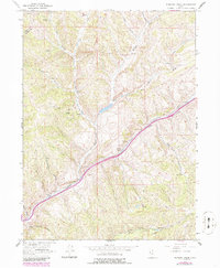
Editions of this 1964 Heiners Creek Map
2 editions found
Other maps of this area

1885 · Salt Lake
USGS Topo · 1:250,000

1900 · Coalville
USGS Topo · 1:125,000

1903 · Coalville
USGS Topo · 1:125,000

1954 · Salt Lake City
USGS Topo · 1:250,000

1954 · Ogden
USGS Topo · 1:250,000

1958 · Ogden
USGS Topo · 1:250,000

1958 · Salt Lake City
USGS Topo · 1:250,000

1960 · Ogden
USGS Topo · 1:250,000

1960 · Salt Lake City
USGS Topo · 1:250,000

1964 · Lost Creek Dam
USGS Topo · 1:24,000