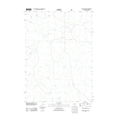
2012 Map of Heinne Creek
USGS Topo · Published 2012About this map
Lone Butte stands as a prominent topographical anchor in this section of the Great Plains, overlooking a landscape defined by an intricate network of seasonal drainages. The hydrology of the region is centered on the westward-flowing Slim Butte Cr and the winding course of Heinne Cr, which together with Allen Cr and Madden Cr create a complex system of draws and breaks. This rural terrain, situated along the South Dakota and Nebraska border, shows a sparse but organized infrastructure of county and forest roads. The presence of Co HWY 3 and secondary routes like Co HWY 3b and FR 3a indicates a landscape managed for ranching and transit, where the natural contours of the land dictate the placement of human thoroughfares across the open prairie.
Find a feature on this map
15 named features on this map. Tap any name to fly to it.
Don’t see what you’re looking for? This feature index may not catch every label — zoom into the map to look around manually.
Map Details
Editions of this 2012 Heinne Creek Map
This is the sole edition of this map. No revisions or reprints were ever made.
Other maps of this area

1896 · Oelrichs
USGS Topo · 1:125,000

1900 · Oelrichs
USGS Topo · 1:125,000

1955 · Hot Springs
USGS Topo · 1:250,000

1955 · Alliance
USGS Topo · 1:250,000

1957 · Alliance
USGS Topo · 1:250,000

1958 · Alliance
USGS Topo · 1:250,000

1967 · Slim Butte SW
USGS Topo · 1:24,000

1967 · Slim Butte NW
USGS Topo · 1:24,000
1970 · Bohemian Creek
USGS Topo · 1:24,000
1970 · Isinglass Buttes
USGS Topo · 1:24,000