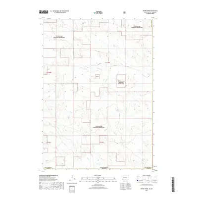
2017 Map of Heinne Creek
USGS Topo · Published 2017About this map
Buffalo Gap National Grassland dominates this South Dakota landscape, where the high plains transition across the border into Nebraska. The terrain is defined by a network of drainage systems including Slim Butte Cr and Heinne Cr, which carve through the arid topography. This 2017 survey illustrates a sparsely populated region primarily managed for conservation and grazing, with Lone Butte serving as a prominent local landmark near the northern boundary. The map captures the meeting point of Fall River Co and Dawes Co along the state line, revealing a remote infrastructure of forest and county roads such as Co HWY 3 and FR 3a. This modern topographic study provides an essential record of the prairie environment and public land management in the northern Great Plains.
Find a feature on this map
18 named features on this map. Tap any name to fly to it.
Don’t see what you’re looking for? This feature index may not catch every label — zoom into the map to look around manually.
Map Details
Editions of this 2017 Heinne Creek Map
This is the sole edition of this map. No revisions or reprints were ever made.
Other maps of this area

1896 · Oelrichs
USGS Topo · 1:125,000

1900 · Oelrichs
USGS Topo · 1:125,000

1955 · Hot Springs
USGS Topo · 1:250,000

1955 · Alliance
USGS Topo · 1:250,000

1957 · Alliance
USGS Topo · 1:250,000

1958 · Alliance
USGS Topo · 1:250,000

1967 · Slim Butte SW
USGS Topo · 1:24,000

1967 · Slim Butte NW
USGS Topo · 1:24,000
1970 · Bohemian Creek
USGS Topo · 1:24,000
1970 · Isinglass Buttes
USGS Topo · 1:24,000