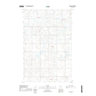
2017 Map of Helde Lake
USGS Topo · Published 2017About this map
Helde Lake and the surrounding prairie pothole region of Burke County dominate this landscape, characterized by a dense network of glacial wetlands and small water bodies. The terrain is defined by its numerous depressions, including Sand Bottom Lake, Swim Lake, and the elongated Sand Slough, which reflect the post-glacial topography of the Northern Plains. A systematic grid of section-line roads, such as Co Rd 11 and 87th St NW, provides access across the township boundaries of t161n r92w, t160n r92w, and t159n r92w. This land-use pattern indicates a predominantly agricultural focus, where the irregular shapes of Jud Christs Lake and Island Lake break the rigid geometry of the rural road system. The mapping of these ephemeral and permanent water features offers a detailed record of the local hydrology prior to modern drainage or conservation shifts.
Find a feature on this map
25 named features on this map. Tap any name to fly to it.
Don’t see what you’re looking for? This feature index may not catch every label — zoom into the map to look around manually.
Map Details
Editions of this 2017 Helde Lake Map
This is the sole edition of this map. No revisions or reprints were ever made.
Other maps of this area

1948 · Beaver Lake
USGS Topo · 1:24,000

1948 · Woburn
USGS Topo · 1:24,000

1949 · Rennie Lake
USGS Topo · 1:24,000

1950 · Flaxton
USGS Topo · 1:62,500

1950 · Portal
USGS Topo · 1:62,500

1953 · Williston
USGS Topo · 1:250,000

1957 · Williston
USGS Topo · 1:250,000
1974 · Thompson Lake
USGS Topo · 1:24,000
1974 · Helde Lake
USGS Topo · 1:24,000

1974 · Grubb Lake
USGS Topo · 1:24,000