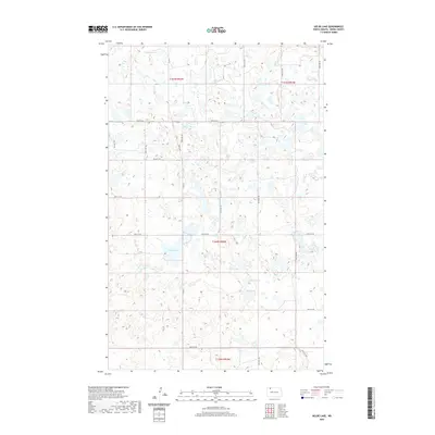
2020 Map of Helde Lake
USGS Topo · Published 2020About this map
Helde Lake anchors a landscape defined by the prairie pothole region of Burke County, where numerous small basins and wetlands dot the terrain. The presence of Johnsons Lake in the north and Jud-Chrests Lake to the northeast illustrates a glaciated geography where water collection is central to the land's character. Significant local thoroughfares including Kings Hwy and Co Rd 11 provide the primary framework for movement across this rural area, connecting the various township and range sections. The map reveals a highly structured grid system typical of the Great Plains, where section lines like 90th St NW and 87th Ave NW dictate the layout of homesteads and local transit. Natural features such as Swim Lake and the marshy Sand Slough highlight the complex hydrology that continues to influence land use and navigation in this part of North Dakota.
Find a feature on this map
27 named features on this map. Tap any name to fly to it.
Don’t see what you’re looking for? This feature index may not catch every label — zoom into the map to look around manually.
Map Details
Editions of this 2020 Helde Lake Map
This is the sole edition of this map. No revisions or reprints were ever made.
Other maps of this area

1948 · Beaver Lake
USGS Topo · 1:24,000

1948 · Woburn
USGS Topo · 1:24,000

1949 · Rennie Lake
USGS Topo · 1:24,000

1950 · Flaxton
USGS Topo · 1:62,500

1950 · Portal
USGS Topo · 1:62,500

1953 · Williston
USGS Topo · 1:250,000

1957 · Williston
USGS Topo · 1:250,000
1974 · Thompson Lake
USGS Topo · 1:24,000
1974 · Helde Lake
USGS Topo · 1:24,000

1974 · Grubb Lake
USGS Topo · 1:24,000