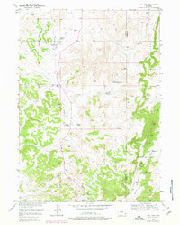
1950 Map of Hell Gap
USGS Topo · Published 1978About this map
The Wild Cat Hills dominate this section of the Wyoming landscape along the border of Platte and Goshen counties. This mid-century survey reveals a territory defined by ranching and resource extraction, with many family names recorded on the land such as the Old 4J Ranch, Brownrigg Ranch, and the Muthart Place. Evidence of changing local infrastructure appears at the Patten Creek Sch (Aban'd), while industrial history is noted at the Greenhope Mine (Inactive) near the eastern hills. The topography is deeply carved by drainages like Whalen Canyon and Patten Creek, leading toward the distinct geological formation known as Hell Gap. These water sources, including Broom Cr Spring and Patten Creek Spring, provided essential points for settlement and livestock in an otherwise arid environment, connected by local routes like the Webb Canyon Road.
Find a feature on this map
19 named features on this map. Tap any name to fly to it.
Don’t see what you’re looking for? This feature index may not catch every label — zoom into the map to look around manually.
Map Details
Editions of this 1950 Hell Gap Map
3 editions found
Other maps of this area

1896 · Hartville
USGS Topo · 1:125,000

1901 · Hartville
USGS Topo · 1:125,000

1949 · Cedar Top
USGS Topo · 1:24,000

1950 · Cedar Top
USGS Topo · 1:24,000

1950 · Guernsey
USGS Topo · 1:24,000

1950 · Casebier Hill
USGS Topo · 1:24,000

1950 · Haushar Ranch
USGS Topo · 1:24,000

1950 · Hell Gap
USGS Topo · 1:24,000

1950 · Guernsey Reservoir
USGS Topo · 1:24,000

1951 · Haushar Ranch
USGS Topo · 1:24,000