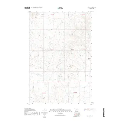
2020 Map of Hell Hollow
USGS Topo · Published 2020About this map
Hell Hollow and the surrounding drainage basins of Garfield County define this 2020 landscape, where the seasonal waters of Snow Cr and its S Fork Snow Cr have carved a complex network of coulees and breaks. The terrain is marked by prominent elevations such as Baldy Butte, which rises above a landscape primarily organized by the Public Land Survey System, as seen in the clear township and range divisions like t21n r35e. Access throughout this high-plains environment is maintained by a sparse network of gravel and unimproved roads, including Hubbard Rd and the aptly named Lone Star Loop. To the north, the geography is further divided by Widow Coulee and East Hill Coulee, illustrating the erosional patterns characteristic of this part of eastern Montana. This survey serves as a clear record of modern ranching and land use patterns, emphasizing the remote nature of the terrain between the region's scattered buttes and ephemeral creek beds.
Find a feature on this map
16 named features on this map. Tap any name to fly to it.
Don’t see what you’re looking for? This feature index may not catch every label — zoom into the map to look around manually.
Map Details
Editions of this 2020 Hell Hollow Map
This is the sole edition of this map. No revisions or reprints were ever made.
Other maps of this area
1954 · Jordan
USGS Topo · 1:250,000
1956 · Jordan
USGS Topo · 1:250,000
1958 · Jordan
USGS Topo · 1:250,000
1964 · Jordan
USGS Topo · 1:250,000
1971 · Hell Hollow
USGS Topo · 1:24,000
1971 · Trumbo Ranch
USGS Topo · 1:24,000
1971 · Wolfe Coulee
USGS Topo · 1:24,000
1971 · Wagon Coulee
USGS Topo · 1:24,000
1971 · Harper Camp
USGS Topo · 1:24,000
1971 · Chalk Butte
USGS Topo · 1:24,000