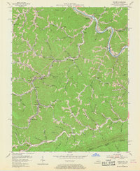
1954 Map of Hellier
USGS Topo · Published 1968About this map
Hellier and the winding course of Marrowbone Creek define this mid-century portrait of Pike County's coal country. The landscape is a complex network of narrow hollows and steep ridges, where industry and community are tightly packed along the creek beds. The extraction economy of the 1950s is evident in the presence of the Allegheny Mine, scattered Strip Mine operations, and the historic Coke Ovens near Edgewater. Transportation is dominated by the Chesapeake And Ohio railroad, which snakes through the valleys to serve the mining settlements of Wolfpit, Draffin, and Lookout. Rural life is centered around a dense concentration of local institutions, including the High Sch at Hellier and several neighborhood schools like the Jackson Br Sch and Upper Greasy Sch. Dozens of family burial grounds, often labeled simply as Cems, dot the hillsides above the residential clusters, while the Pine Mountain boundary marks the southern edge of the survey area.
Find a feature on this map
82 named features on this map. Tap any name to fly to it.
Don’t see what you’re looking for? This feature index may not catch every label — zoom into the map to look around manually.
Map Details
Editions of this 1954 Hellier Map
3 editions found
Other maps of this area

1886 · Grundy
USGS Topo · 1:125,000

1890 · Whitesburg
USGS Topo · 1:125,000

1890 · Grundy
USGS Topo · 1:125,000

1892 · Grundy
USGS Topo · 1:125,000

1892 · Whitesburg
USGS Topo · 1:125,000

1912 · Pound
USGS Topo · 1:48,000

1913 · Clintwood
USGS Topo · 1:62,500

1914 · Pound
USGS Topo · 1:62,500

1914 · Vergie
USGS Topo · 1:48,000

1915 · Clintwood
USGS Topo · 1:62,500