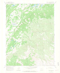
1965 Map of Hells Kitchen
USGS Topo · Published 1968About this map
Grand Mesa National Forest dominates this mid-1960s landscape, revealing a complex network of high-altitude water management and mineral extraction. The map detail highlights an intricate system of numbered and named reservoirs, including Flowing Park Reservoir, Porter Reservoir No 1, and Dugger Reservoir, which served the irrigation and municipal needs of the surrounding valley. The rugged terrain between Mesa and Delta Counties is marked by steep canyons and pack trails, indicating a landscape where access remained limited to primitive roads like Doughpoon Road.
Find a feature on this map
53 named features on this map. Tap any name to fly to it.
Don’t see what you’re looking for? This feature index may not catch every label — zoom into the map to look around manually.
Map Details
Editions of this 1965 Hells Kitchen Map
3 editions found
Other maps of this area

1955 · Grand Mesa
USGS Topo · 1:24,000

1955 · Skyway
USGS Topo · 1:24,000

1956 · Montrose
USGS Topo · 1:250,000

1956 · Moab
USGS Topo · 1:250,000

1956 · Grand Junction
USGS Topo · 1:250,000

1957 · Leadville
USGS Topo · 1:250,000

1959 · Grand Junction
USGS Topo · 1:250,000

1959 · Moab
USGS Topo · 1:250,000

1959 · Leadville
USGS Topo · 1:250,000

1959 · Montrose
USGS Topo · 1:250,000