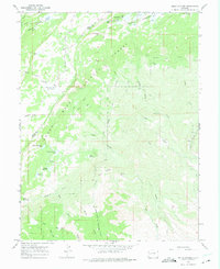
1965 Map of Hells Kitchen
USGS Topo · Published 1975About this map
Grand Mesa National Forest defines the rugged high-elevation terrain where the borders of Mesa and Delta Counties meet. This 1965 field-checked survey reveals an extensive water management network of small high-country reservoirs and ditches, including the Granby Reservoirs and the Flowing Park Reservoir. These systems, connected by features like the Dirty George Creek and Doughspoon Aqueduct, were vital for directing mountain runoff to lower elevations. Small-scale industrial activity is evident in the scattered mining operations across the slopes, such as the Rollins Mine near Beebe Creek and the Fairview Mine located north of Hells Kitchen. For the local historian or outdoorsman, the map traces numerous pack trails like the Bull and Brown Trail, which once provided the primary access for livestock and early resource extraction across this complex landscape of creeks and canyons.
Find a feature on this map
54 named features on this map. Tap any name to fly to it.
Don’t see what you’re looking for? This feature index may not catch every label — zoom into the map to look around manually.
Map Details
Editions of this 1965 Hells Kitchen Map
3 editions found
Other maps of this area

1955 · Grand Mesa
USGS Topo · 1:24,000

1955 · Skyway
USGS Topo · 1:24,000

1956 · Montrose
USGS Topo · 1:250,000

1956 · Moab
USGS Topo · 1:250,000

1956 · Grand Junction
USGS Topo · 1:250,000

1957 · Leadville
USGS Topo · 1:250,000

1959 · Grand Junction
USGS Topo · 1:250,000

1959 · Moab
USGS Topo · 1:250,000

1959 · Leadville
USGS Topo · 1:250,000

1959 · Montrose
USGS Topo · 1:250,000