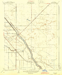
1925 Map of Helm
USGS Topo · Published 1944About this map
Helm serves as a central point in this 1920s agricultural landscape, situated where the Southern Pacific railroad line intersects the grid of the Central Valley. The map reveals the intricate water management system essential to the region, dominated by the winding course of Fresno Slough and the engineered precision of the Main Bypass and Stinson Canal. A Diversion Dam positioned along the slough highlights the early infrastructure used to redirect water for irrigation across the surrounding plains. The rural character of the era is evidenced by the solitary New Hope School south of the town site, serving a dispersed population connected by an emerging network of named thoroughfares like Madera Avenue and Coalinga Road. This survey captures a moment when mechanical irrigation and rail transport were fundamentally reshaping the geography of Fresno County.
Find a feature on this map
13 named features on this map. Tap any name to fly to it.
Don’t see what you’re looking for? This feature index may not catch every label — zoom into the map to look around manually.
Map Details
Editions of this 1925 Helm Map
2 editions found
Other maps of this area

1912 · Coalinga
USGS Topo · 1:125,000

1923 · Kearney Park
USGS Topo · 1:31,680

1924 · Jamesan
USGS Topo · 1:31,680

1925 · Helm
USGS Topo · 1:31,680

1925 · San Joaquin
USGS Topo · 1:31,680

1925 · Raisin
USGS Topo · 1:31,680

1927 · Burrel
USGS Topo · 1:31,680

1931 · Wheatville
USGS Topo · 1:31,680

1931 · Towne Oil Station
USGS Topo · 1:31,680
1946 · Kearney Park
USGS Topo · 1:24,000