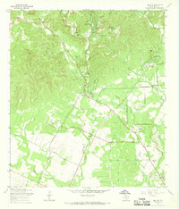
1966 Map of Helotes
USGS Topo · Published 1969About this map
The hills of northwest Bexar County transition into the developing Leon Valley on this 1960s revision. This era captures the semi-rural character of Helotes and Grey Forest before the rapid expansion of San Antonio's outskirts. The landscape is defined by the drainage systems of Leon Creek, Helotes Creek, and Huesta Creek, which carve through the limestone terrain. Local history and genealogy interests are well-served by the inclusion of several family and community landmarks, such as Menchaca Cem, Lee Cem, and Helotes Cem.
Find a feature on this map
33 named features on this map. Tap any name to fly to it.
Don’t see what you’re looking for? This feature index may not catch every label — zoom into the map to look around manually.
Map Details
Editions of this 1966 Helotes Map
Other maps of this area

1953 · Otis Ridge
USGS Topo · 1:24,000

1953 · Culebra Hill
USGS Topo · 1:24,000

1953 · San Antonio West
USGS Topo · 1:24,000

1953 · Helotes
USGS Topo · 1:24,000

1953 · Castle Hills
USGS Topo · 1:24,000

1953 · Van Raub
USGS Topo · 1:24,000

1954 · San Antonio
USGS Topo · 1:250,000

1956 · Medina Lake
USGS Topo · 1:62,500

1957 · San Antonio
USGS Topo · 1:250,000

1958 · La Coste NE
USGS Topo · 1:24,000