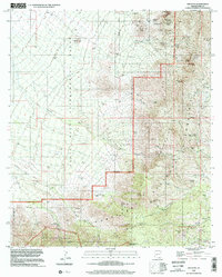
1996 Map of Helvetia
USGS Topo · Published 2002About this map
Mining history and ranching life define this section of Pima County, where the remnants of several late-19th and early-20th century mining operations are scattered across the landscape. The Helvetia settlement and the nearby Helvetia Cem serve as focal points for local history, illustrating the boom-and-bust cycle of Arizona copper mining. Numerous named mines including the Bulldozer Mine, Copper World Mine, and Wisconsin Mine are concentrated near the northern peaks, while Greaterville occupies the southeastern corner.
Find a feature on this map
78 named features on this map. Tap any name to fly to it.
Don’t see what you’re looking for? This feature index may not catch every label — zoom into the map to look around manually.
Map Details
Editions of this 1996 Helvetia Map
This is the sole edition of this map. No revisions or reprints were ever made.
Other maps of this area

1904 · Patagonia
USGS Topo · 1:125,000

1905 · Patagonia
USGS Topo · 1:125,000

1922 · Agus Caliente
USGS Topo · 1:62,500

1926 · Helvetia
USGS Topo · 1:62,500

1932 · Elgin
USGS Topo · 1:62,500

1940 · Elgin
USGS Topo · 1:62,500

1947 · Elgin
USGS Topo · 1:62,500

1948 · Sonoita
USGS Topo · 1:24,000

1956 · Nogales
USGS Topo · 1:250,000

1958 · Nogales
USGS Topo · 1:250,000