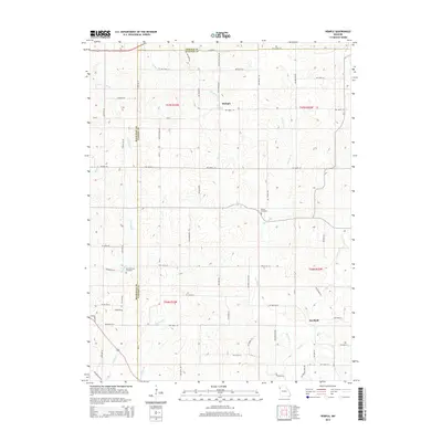
2014 Map of Hemple
USGS Topo · Published 2014About this map
The agrarian borderlands where DeKalb, Clinton, and Buchanan counties converge are defined by a dense network of watercourses and section roads. The small settlement of Hemple sits near the headwaters of Jordan Cr and Roger Br, while further south, the crossroads of Starfield marks the landscape near Castile Cr. This modern survey illustrates how traditional land divisions persist, with cemeteries such as Keller Cemetery and New Harmony Cemetery serving as fixed points of local heritage amidst the fields. Drainage patterns are intricate here, as numerous branches including McGuire Br, Jenkins Br, and Wolfpen Cr carve the terrain. The presence of NW 316th St and NW Kerns Rd reflects the established grid of Northwest Missouri's rural infrastructure, maintaining connectivity between family farms and these long-standing community centers.
Find a feature on this map
62 named features on this map. Tap any name to fly to it.
Don’t see what you’re looking for? This feature index may not catch every label — zoom into the map to look around manually.
Map Details
Editions of this 2014 Hemple Map
This is the sole edition of this map. No revisions or reprints were ever made.
Other maps of this area

1923 · Clarksdale
USGS Topo · 1:62,500

1923 · Maysville
USGS Topo · 1:62,500

1925 · Gower
USGS Topo · 1:62,500

1925 · Clarksdale
USGS Topo · 1:62,500

1925 · Plattsburg
USGS Topo · 1:62,500

1925 · Maysville
USGS Topo · 1:62,500

1950 · Kansas City
USGS Topo · 1:250,000

1951 · Edgerton
USGS Topo · 1:24,000
1951 · Gower
USGS Topo · 1:24,000

1954 · Kansas City
USGS Topo · 1:250,000