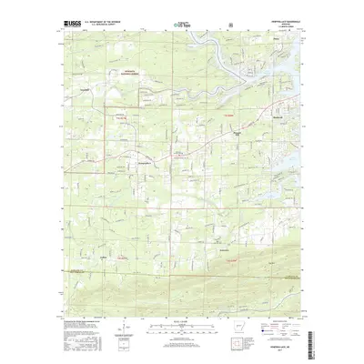
2017 Map of Hempwallace
USGS Topo · Published 2017About this map
Ouachita National Forest blankets the northwestern corner of this landscape, where the terrain slopes down toward the waters of Mazarn Creek and Kelly Cr. This 2017 survey details the residential expansion south of Hot Springs, anchored by the settlement of Hempwallace and the lakeside development around Lake Hamilton. The transition from the forested ridges of Trap Mtn in the south to the established communities of Rockwell and Pleasant Hill illustrates the shift from timbered wilderness to suburban infill. Genealogists and local historians can pinpoint several significant burial grounds, including the Oak Grove Cem and the Aldrich Cem, which remain tucked among the winding county roads. The map also records the hydrological divide between the Rush Fork drainage and the larger Lake Hamilton basin, showing how the local road network, including Airport Rd, has shaped the growth of these Garland and Hot Spring County neighborhoods.
Find a feature on this map
106 named features on this map. Tap any name to fly to it.
Don’t see what you’re looking for? This feature index may not catch every label — zoom into the map to look around manually.
Map Details
Editions of this 2017 Hempwallace Map
This is the sole edition of this map. No revisions or reprints were ever made.
Other maps of this area

1890 · Hot Springs
USGS Topo · 1:125,000

1894 · Hot Springs
USGS Topo · 1:125,000

1955 · Little Rock
USGS Topo · 1:250,000

1956 · Little Rock
USGS Topo · 1:250,000

1960 · Little Rock
USGS Topo · 1:250,000

1962 · Crystal Springs
USGS Topo · 1:24,000

1964 · Little Rock
USGS Topo · 1:250,000

1966 · Pearcy
USGS Topo · 1:24,000
1966 · Hot Springs North
USGS Topo · 1:24,000

1966 · Hempwallace
USGS Topo · 1:24,000