
1966 Map of Pearcy
USGS Topo · Published 1967About this map
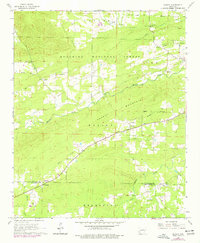
Pearcy and the surrounding rural communities of Meyers, Maddox, and Oma anchor this mid-1960s survey of the Arkansas countryside. The landscape is defined by the sharp transition from the elevated terrain of Mazarn Mountain and Lee Mountain down into the valley floor. Much of the northern half of the quadrangle is protected within the Ouachita National Forest, where clearings for settlements like Chandler contrast with the dense timber of the federal lands.
Find a feature on this map
23 named features on this map. Tap any name to fly to it.
Don’t see what you’re looking for? This feature index may not catch every label — zoom into the map to look around manually.
Map Details
Editions of this 1966 Pearcy Map
2 editions found
Other maps of this area

1890 · Hot Springs
USGS Topo · 1:125,000

1894 · Hot Springs
USGS Topo · 1:125,000

1955 · Little Rock
USGS Topo · 1:250,000

1956 · Little Rock
USGS Topo · 1:250,000

1960 · Little Rock
USGS Topo · 1:250,000

1962 · Crystal Springs
USGS Topo · 1:24,000

1962 · Mc Graw Mountain
USGS Topo · 1:24,000

1964 · Little Rock
USGS Topo · 1:250,000

1966 · Hempwallace
USGS Topo · 1:24,000
1966 · Bonnerdale
USGS Topo · 1:24,000