
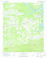
1966 Map of Hempwallace
USGS Topo · Published 1967About this map
Lake Hamilton dominates the northeastern portion of this mid-century landscape, where the Ouachita River winds through the protected lands of the Ouachita National Forest. The transition from river to reservoir reflects the 20th-century development of the region, while the surrounding hills remain dotted with small rural communities like Hempwallace, Sunshine, and Pleasant Hill. An Old Railroad Grade cuts across the center of the sheet, tracing a former path of industry through the wooded terrain near the Memorial Gardens Cem.
Find a feature on this map
40 named features on this map. Tap any name to fly to it.
Don’t see what you’re looking for? This feature index may not catch every label — zoom into the map to look around manually.
Map Details
Editions of this 1966 Hempwallace Map
2 editions found
Other maps of this area

1890 · Hot Springs
USGS Topo · 1:125,000

1894 · Hot Springs
USGS Topo · 1:125,000

1955 · Little Rock
USGS Topo · 1:250,000

1956 · Little Rock
USGS Topo · 1:250,000

1960 · Little Rock
USGS Topo · 1:250,000

1962 · Crystal Springs
USGS Topo · 1:24,000

1964 · Little Rock
USGS Topo · 1:250,000

1966 · Pearcy
USGS Topo · 1:24,000
1966 · Hot Springs North
USGS Topo · 1:24,000

1966 · De Roche
USGS Topo · 1:24,000