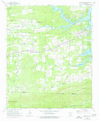
1966 Map of Hempwallace
USGS Topo · Published 1977About this map
Lake Hamilton dominates the eastern landscape of this 1966 survey, where the Ouachita River winds through the northern hills of the Ouachita National Forest. The map captures a rural network of small communities such as Hempwallace, Sunshine, and Pleasant Hill, connected by winding roads and an Old Railroad Grade that speaks to the area's earlier industrial transport.
Find a feature on this map
38 named features on this map. Tap any name to fly to it.
Don’t see what you’re looking for? This feature index may not catch every label — zoom into the map to look around manually.
Map Details
Editions of this 1966 Hempwallace Map
2 editions found
Other maps of this area

1890 · Hot Springs
USGS Topo · 1:125,000

1894 · Hot Springs
USGS Topo · 1:125,000

1955 · Little Rock
USGS Topo · 1:250,000

1956 · Little Rock
USGS Topo · 1:250,000

1960 · Little Rock
USGS Topo · 1:250,000

1962 · Crystal Springs
USGS Topo · 1:24,000

1964 · Little Rock
USGS Topo · 1:250,000

1966 · Pearcy
USGS Topo · 1:24,000
1966 · Hot Springs North
USGS Topo · 1:24,000

1966 · Hempwallace
USGS Topo · 1:24,000