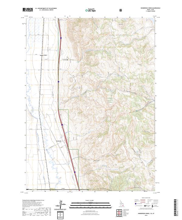
2023 Map of Henderson Creek
USGS Topo · Published 2023About this map
Malad Valley serves as a primary corridor for travel and agriculture along the Idaho-Utah border, where the western foothills of the Malad Range meet the valley floor. The small settlement of Woodruff and the community at Cherry Creek anchor the local geography, with the latter featuring the Cherry Creek Cem near the banks of its namesake waterway. This landscape is defined by the management of water in an arid environment, seen in the path of the Malad River and the engineering of the Samaria Lake Canal. To the east, the terrain rises sharply into the Caribou National Forest, a region cut by deep drainages such as Burnett Canyon and Black Canyon. Numerous springs, including Willow Spring and Cold Spring, dot the higher elevations, providing vital water sources for the cattle and wildlife that move through these public lands.
Find a feature on this map
48 named features on this map. Tap any name to fly to it.
Don’t see what you’re looking for? This feature index may not catch every label — zoom into the map to look around manually.
Map Details
Editions of this 2023 Henderson Creek Map
This is the sole edition of this map. No revisions or reprints were ever made.
Other maps of this area

1954 · Pocatello
USGS Topo · 1:250,000

1954 · Brigham City
USGS Topo · 1:250,000

1958 · Pocatello
USGS Topo · 1:250,000

1958 · Brigham City
USGS Topo · 1:250,000

1962 · Brigham City
USGS Topo · 1:250,000
1964 · Clarkston
USGS Topo · 1:24,000
1964 · Portage
USGS Topo · 1:24,000

1968 · Samaria
USGS Topo · 1:24,000

1968 · Malad City West
USGS Topo · 1:24,000

1968 · Malad City East
USGS Topo · 1:24,000