1991 Map of Henderson
USGS Topo · Published 1991About this map
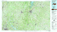
The John H. Kerr Reservoir and Falls Lake dominate the hydrography of this North Carolina borderland, shaping the modern recreation and water management profile of Vance and Granville Counties. This 1991 revision, compiled from earlier surveys and 1980s aerial photography, captures the region's transport network anchored by the Seaboard Coast Line RR and Southern Railway lines that historically fueled the growth of towns like Henderson and Oxford.
Find a feature on this map
120 named features on this map. Tap any name to fly to it.
Don’t see what you’re looking for? This feature index may not catch every label — zoom into the map to look around manually.
Map Details
Editions of this 1991 Henderson Map
2 editions found

Other maps of this area

1902 · Rocky Mount
USGS Topo · 1:62,500

1902 · Spring Hope
USGS Topo · 1:62,500

1904 · Rocky Mount
USGS Topo · 1:62,500

1904 · Springhope
USGS Topo · 1:62,500

1919 · White Plains
USGS Topo · 1:48,000

1920 · White Plains
USGS Topo · 1:62,500

1941 · Clarksville
USGS Topo · 1:48,000

1943 · Durham South
USGS Topo · 1:62,500

1943 · Clarksville
USGS Topo · 1:62,500

1943 · Raleigh
USGS Topo · 1:62,500