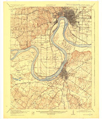
1916 Map of Henderson
USGS Topo · Published 1925About this map
The Ohio River dominates this 1914 survey, carving a massive oxbow known as Cypress Bend between the burgeoning industrial centers of Evansville and Henderson. This stretch of the river, crucial for regional commerce, features Lock and Dam No 48 and numerous sloughs such as Atkinson Slough and Bennett Slough that indicate the complex hydrology of the bottomlands. The map reveals a densely settled rural landscape defined by an extensive network of school districts, including St Johns School, Corkie School, and Double A School, reflecting the community structure of the early twentieth century.
Find a feature on this map
101 named features on this map. Tap any name to fly to it.
Don’t see what you’re looking for? This feature index may not catch every label — zoom into the map to look around manually.
Map Details
Editions of this 1916 Henderson Map
3 editions found

Other maps of this area

1901 · Haubstadt
USGS Topo · 1:62,500

1902 · Ditney
USGS Topo · 1:125,000

1902 · Boonville
USGS Topo · 1:62,500

1903 · Haubstadt
USGS Topo · 1:62,500

1903 · New Harmony
USGS Topo · 1:62,500

1903 · Patoka
USGS Topo · 1:125,000

1905 · Newburg
USGS Topo · 1:62,500

1906 · Sebree
USGS Topo · 1:62,500

1907 · Morganfield
USGS Topo · 1:62,500

1908 · Calhoun
USGS Topo · 1:62,500