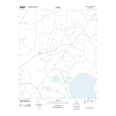
2011 Map of Henderson Still
USGS Topo · Published 2011About this map
Henderson Still anchors this pocket of Atkinson County, Georgia, situated in a landscape defined by the expansive wet terrain of Sow Bay. The local geography is marked by a network of drainage ways including Hog Creek and Mud Creek, while the rural road system preserves family and historical names such as Waldo Henderson Rd and Captain John Smith Rd. The nomenclature of the area, notably the references to stills found in labels like 5 Mile Still Rd, provides a subtle link to the region's historical turpentine or naval stores industry. This late 20th and early 21st-century documentation captures the intersection of traditional land use and modern infrastructure, shown through the various county routes that crisscross the low-lying wetlands and timberlands.
Find a feature on this map
33 named features on this map. Tap any name to fly to it.
Don’t see what you’re looking for? This feature index may not catch every label — zoom into the map to look around manually.
Map Details
Editions of this 2011 Henderson Still Map
This is the sole edition of this map. No revisions or reprints were ever made.
Other maps of this area

1953 · Waycross
USGS Topo · 1:250,000

1958 · Waycross
USGS Topo · 1:250,000

1968 · Lakeland
USGS Topo · 1:24,000

1971 · Pearson
USGS Topo · 1:24,000

1972 · Kirkland
USGS Topo · 1:24,000

1972 · Willacoochee
USGS Topo · 1:24,000

1972 · Sirmans
USGS Topo · 1:24,000

1972 · Sandy Bottom
USGS Topo · 1:24,000

1972 · Henderson Still
USGS Topo · 1:24,000
1977 · Hastings Fish Pond
USGS Topo · 1:24,000