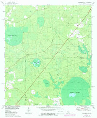
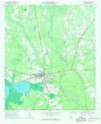
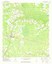
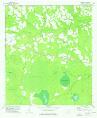
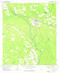
1972 Map of Henderson Still
USGS Topo · Published 1987About this map
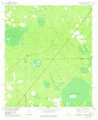
Henderson Still marks a significant local landmark in this pocket of the Georgia wiregrass country, where the landscape is defined by an intricate network of shallow depressions known as bays and expansive wetlands. The terrain is a mosaic of swampy lowlands and pine flatwoods, including the massive Arabia Swamp in the southeast and the curiously named Fifty Dollar Bay. Evidence of the region’s forestry and turpentine heritage is anchored by the Lookout Tower near the meeting of Atkinson, Lanier, and Clinch counties. The rural social fabric of the early 1970s is preserved through the location of small country churches like Ozias Ch and Salem Ch, along with an unnamed Cem, serving the dispersed homesteads connected by sandy tracks like Brinson Road and Courson Road.
Find a feature on this map
35 named features on this map. Tap any name to fly to it.
Don’t see what you’re looking for? This feature index may not catch every label — zoom into the map to look around manually.
Map Details
Editions of this 1972 Henderson Still Map
This is the sole edition of this map. No revisions or reprints were ever made.
Other maps of this area

1953 · Waycross
USGS Topo · 1:250,000

1958 · Waycross
USGS Topo · 1:250,000
1968 · Lakeland
USGS Topo · 1:24,000
1971 · Pearson
USGS Topo · 1:24,000
1972 · Kirkland
USGS Topo · 1:24,000
1972 · Willacoochee
USGS Topo · 1:24,000
1972 · Sirmans
USGS Topo · 1:24,000
1972 · Sandy Bottom
USGS Topo · 1:24,000
1977 · Hastings Fish Pond
USGS Topo · 1:24,000
1978 · Henderson Still
USGS Topo · 1:24,000