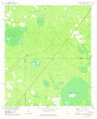
1978 Map of Henderson Still
USGS Topo · Published 1978About this map
Arabia Swamp and a series of expansive shallow basins dominate this Georgia landscape at the intersection of Atkinson, Clinch, and Lanier Counties. The terrain is defined by its namesake "bays" — elliptical depressions such as Featherbed Bay, Wolf Bay, and the uniquely named Fifty Dollar Bay. Settlement is sparse, anchored by Henderson Still where a Lookout Tower stands watch over the pine-rich lowlands and wetlands. The map details the rural infrastructure of the 1970s, showing quiet country roads like Brinson Road and Courson Road cutting through the dense vegetation. Religious and community life is centered at Ozias Ch and Salem Ch, the latter accompanied by a small Cem. The drainage patterns of Hog Creek and Mud Creek further illustrate the hydrologic complexity of this part of the coastal plain, where Bee Pond Flats and Sow Bay create a labyrinth of seasonal water and swampy bottomland.
Find a feature on this map
24 named features on this map. Tap any name to fly to it.
Don’t see what you’re looking for? This feature index may not catch every label — zoom into the map to look around manually.
Map Details
Editions of this 1978 Henderson Still Map
This is the sole edition of this map. No revisions or reprints were ever made.
Other maps of this area

1953 · Waycross
USGS Topo · 1:250,000

1958 · Waycross
USGS Topo · 1:250,000

1968 · Lakeland
USGS Topo · 1:24,000

1971 · Pearson
USGS Topo · 1:24,000

1972 · Kirkland
USGS Topo · 1:24,000

1972 · Willacoochee
USGS Topo · 1:24,000

1972 · Sirmans
USGS Topo · 1:24,000

1972 · Sandy Bottom
USGS Topo · 1:24,000

1972 · Henderson Still
USGS Topo · 1:24,000
1977 · Hastings Fish Pond
USGS Topo · 1:24,000