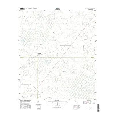
2017 Map of Henderson Still
USGS Topo · Published 2017About this map
Henderson Still marks a distinct crossroads in this south Georgia landscape where the borders of Atkinson, Lanier, and Clinch counties meet. The area is characterized by an intricate network of wetlands and namesake bays, including the curiously named Fifty Dollar Bay and the extensive Arabia Swamp to the southeast. These topographical features suggest a history of naval stores and timber extraction, common to the Wiregrass Region. Local landmarks such as Featherbed Bay and Bee Pond Flats are interspersed among a grid of rural roads named for established families and landmarks, such as Waldo Henderson Rd, Boots Gillis Rd, and Johnson Settlement Rd. The drainage patterns of Hog Creek and Mud Cr further define the damp, low-lying terrain that influenced the early settlement and road placement throughout this portion of the coastal plain.
Find a feature on this map
52 named features on this map. Tap any name to fly to it.
Don’t see what you’re looking for? This feature index may not catch every label — zoom into the map to look around manually.
Map Details
Editions of this 2017 Henderson Still Map
This is the sole edition of this map. No revisions or reprints were ever made.
Other maps of this area

1953 · Waycross
USGS Topo · 1:250,000

1958 · Waycross
USGS Topo · 1:250,000

1968 · Lakeland
USGS Topo · 1:24,000

1971 · Pearson
USGS Topo · 1:24,000

1972 · Kirkland
USGS Topo · 1:24,000

1972 · Willacoochee
USGS Topo · 1:24,000

1972 · Sirmans
USGS Topo · 1:24,000

1972 · Sandy Bottom
USGS Topo · 1:24,000

1972 · Henderson Still
USGS Topo · 1:24,000
1977 · Hastings Fish Pond
USGS Topo · 1:24,000