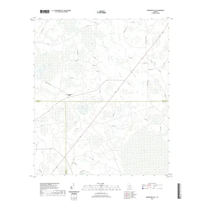
2020 Map of Henderson Still
USGS Topo · Published 2020About this map
Henderson Still sits at the convergence of Atkinson, Lanier, and Clinch Counties, marking a landscape defined by the expansive wetlands of South Georgia. This modern survey illustrates a network of distinctive "bays"—shallow, oval depressions characteristic of the coastal plain—including Featherbed Bay, Mullis Bay, and the curiously named Fifty Dollar Bay. These features, along with the sprawling Arabia Swamp and Bee Pond Flats, dominate the hydrology of the region. The map provides a detailed view of the rural infrastructure connecting these natural features, from the straight line of Mule Lot Rd to family-named routes like George Cowart Rd and J N Corbitt Rd. The drainage pattern is dictated by sluggish watercourses such as Hog Cr and Mud Cr, which thread through the dense pine and swamp environment.
Find a feature on this map
53 named features on this map. Tap any name to fly to it.
Don’t see what you’re looking for? This feature index may not catch every label — zoom into the map to look around manually.
Map Details
Editions of this 2020 Henderson Still Map
This is the sole edition of this map. No revisions or reprints were ever made.
Other maps of this area

1953 · Waycross
USGS Topo · 1:250,000

1958 · Waycross
USGS Topo · 1:250,000

1968 · Lakeland
USGS Topo · 1:24,000

1971 · Pearson
USGS Topo · 1:24,000

1972 · Kirkland
USGS Topo · 1:24,000

1972 · Willacoochee
USGS Topo · 1:24,000

1972 · Sirmans
USGS Topo · 1:24,000

1972 · Sandy Bottom
USGS Topo · 1:24,000

1972 · Henderson Still
USGS Topo · 1:24,000
1977 · Hastings Fish Pond
USGS Topo · 1:24,000