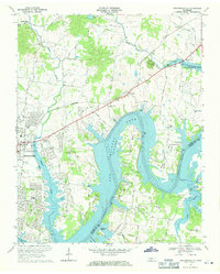
1968 Map of Hendersonville
USGS Topo · Published 1971About this map
Old Hickory Lake dominates the landscape of this late 1960s survey, its winding waters drowning the lower reaches of Drakes Creek and the Cumberland River. The residential expansion of Hendersonville is visible along the western shore, while the surrounding hills retain a network of rural settlements and family-named landmarks. The Louisville and Nashville railroad cuts a straight path across the terrain, passing through Saundersville and Avondale toward the prominent Pilot Knob. This era shows a community in transition from farm land to a suburban recreation hub, evidenced by the numerous boat ramps and Andrew Jackson Camp situated near the water's edge. Local genealogy is well-supported by numerous marked churches like Rehoboth Ch and Little Cedar Lick Ch, alongside several unnamed cemeteries that dot the ridges overlooking the river valley.
Find a feature on this map
52 named features on this map. Tap any name to fly to it.
Don’t see what you’re looking for? This feature index may not catch every label — zoom into the map to look around manually.
Map Details
Editions of this 1968 Hendersonville Map
2 editions found
Other maps of this area

1903 · Nashville
USGS Topo · 1:125,000

1932 · Hermitage
USGS Topo · 1:62,500

1942 · Gallatin
USGS Topo · 1:100,000

1942 · Lebanon
USGS Topo · 1:100,000

1951 · Martha
USGS Topo · 1:24,000

1952 · Goodlettsville
USGS Topo · 1:24,000

1952 · Hendersonville
USGS Topo · 1:24,000

1952 · Hermitage
USGS Topo · 1:24,000

1952 · Nashville East
USGS Topo · 1:24,000

1953 · Cottontown
USGS Topo · 1:24,000