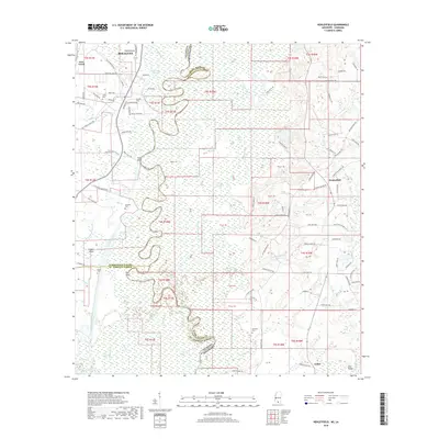
2018 Map of Henleyfield
USGS Topo · Published 2018About this map
Bogalusa sits at the northern edge of this survey where the meandering Pearl River forms the state line between Washington Parish, Louisiana, and Pearl River County, Mississippi. The landscape is dominated by the complex hydrology of the river basin, featuring the Pearl River Canal, deep swamps like Debils Swamp, and numerous oxbow features such as Ox Lot Slough. Settlement patterns are concentrated along the higher ground near the river bluffs, evidenced by sites like Pools Bluff and the prominent Red Bluff. In the Mississippi interior, the community of Henleyfield and the rail-aligned settlement of Cybur anchor the rural landscape. Genealogists will find a wealth of family-named landmarks and local burial sites, including Duffys Cem, Pounds Cem, and McGehee Cem, which reflect the distributed rural population that once lived along the timber-rich corridors of Bogue Chitto and Lees Creek.
Find a feature on this map
113 named features on this map. Tap any name to fly to it.
Don’t see what you’re looking for? This feature index may not catch every label — zoom into the map to look around manually.
Map Details
Editions of this 2018 Henleyfield Map
This is the sole edition of this map. No revisions or reprints were ever made.
Other maps of this area

1942 · Talisheek
USGS Topo · 1:31,680

1942 · Rio
USGS Topo · 1:31,680

1942 · Walkiah Bluff
USGS Topo · 1:31,680

1942 · Pools Bluff
USGS Topo · 1:31,680

1949 · Bogalusa East
USGS Topo · 1:31,680

1949 · Bogalusa West
USGS Topo · 1:31,680

1953 · Mobile
USGS Topo · 1:250,000

1957 · Mobile
USGS Topo · 1:250,000

1958 · Picayune
USGS Topo · 1:62,500

1959 · Bogalusa
USGS Topo · 1:62,500