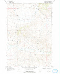
1968 Map of Henry Gulch
USGS Topo · Published 1972About this map
The Red Rock River meanders through the heart of this Beaverhead County landscape, defining the local drainage and topographic character during the late 1960s. The river is flanked by rising terrain where Henry Gulch and Centennial Gulch converge from the south, illustrating the drainage patterns that shaped early ranching and water rights in this corner of Montana. Evidence of human presence is sparse on this high-country sheet, with the isolated Chris Cabin standing as a solitary landmark near the headwaters of Basin Creek. Numerous unnamed Spring and Springs labels across the ridges suggest a landscape where water sources were critical for the few livestock operations managed within the township and range boundaries. This map captures the territory before modern developments, showing a complex network of canyons and gulches like Little Basin Creek in their mid-century state.
Find a feature on this map
9 named features on this map. Tap any name to fly to it.
Don’t see what you’re looking for? This feature index may not catch every label — zoom into the map to look around manually.
Map Details
Editions of this 1968 Henry Gulch Map
2 editions found

Other maps of this area

1955 · Dubois
USGS Topo · 1:250,000

1958 · Dubois
USGS Topo · 1:250,000

1965 · Lima
USGS Topo · 1:24,000

1965 · Rock Island Ranch
USGS Topo · 1:24,000

1965 · Lima Peaks
USGS Topo · 1:24,000

1968 · Whiskey Spring
USGS Topo · 1:24,000

1968 · Lima Dam
USGS Topo · 1:24,000

1968 · Snowline
USGS Topo · 1:24,000

1968 · Vinegar Hill
USGS Topo · 1:24,000

1968 · Monida
USGS Topo · 1:24,000