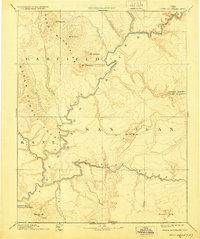
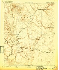
1892 Map of Henry Mountains
USGS Topo · Published 1928About this map
The Henry Mountains dominate the upper portion of this topographic survey, which spans the borderlands between Garfield and San Juan counties during the late 19th and early 20th centuries. This work, based on topography by the Powell Surveys, captures the desert landscape before the era of major dam projects, showing the natural course of the Colorado River as it winds through deep canyons and meets the San Juan River. The intricate contour lines reveal the massive geologic scale of the Water Pocket Fold and the isolated peaks of Mt Hillers and Mt Holmes. This reconstruction illustrates the region as a wild, high-desert frontier where early conservation efforts are noted through labels for Natural Bridges National Monument and Rainbow Bridge National Monument. Further south, the map delineates the Utah Arizona Boundary Line near the iconic landforms of Monument Valley.
Find a feature on this map
24 named features on this map. Tap any name to fly to it.
Don’t see what you’re looking for? This feature index may not catch every label — zoom into the map to look around manually.
Map Details
Editions of this 1892 Henry Mountains Map
6 editions found

Other maps of this area

1883 · Marsh Pass
USGS Topo · 1:250,000

1885 · San Rafael
USGS Topo · 1:250,000

1885 · La Sal
USGS Topo · 1:250,000

1885 · Fish Lake
USGS Topo · 1:250,000

1886 · Escalante
USGS Topo · 1:250,000

1886 · Henry Mountains
USGS Topo · 1:250,000

1886 · Abajo
USGS Topo · 1:250,000

1886 · Echo Cliffs
USGS Topo · 1:250,000

1891 · Echo Cliffs
USGS Topo · 1:250,000

1892 · Marsh Pass
USGS Topo · 1:250,000