
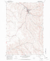
1968 Map of Heppner
USGS Topo · Published 1970About this map
The Morrow County seat of Heppner sits at the confluence of several steep drainages, most notably where Willow Creek and Hinton Creek meet in a narrow valley. This 1968 field-checked survey highlights a established municipal center, featuring the Courthouse, the Pioneer Hospital, and the Masonic Cem on the town's southern edge. The local agricultural economy is anchored by massive Grain Elevators and the Union Pacific rail line, which snakes through Dutton Canyon to reach the valley floor. To the south, the landscape is defined by a series of named canyons like Shobe Canyon, Donaldson Canyon, and Six Dollar Canyon, where numerous springs and storage bins suggest a reliance on water management for ranching. Further south, the map captures the remote character of the Rhea Creek drainage near the border of Morrow and Gilliam counties.
Find a feature on this map
36 named features on this map. Tap any name to fly to it.
Don’t see what you’re looking for? This feature index may not catch every label — zoom into the map to look around manually.
Map Details
Editions of this 1968 Heppner Map
2 editions found
Other maps of this area

1953 · Pendleton
USGS Topo · 1:250,000

1956 · Pendleton
USGS Topo · 1:250,000

1968 · Swaggart Buttes
USGS Topo · 1:24,000

1968 · Lexington
USGS Topo · 1:24,000

1968 · Ruggs
USGS Topo · 1:24,000

1968 · Gleason Butte
USGS Topo · 1:24,000

1968 · Skinners Fork
USGS Topo · 1:24,000

1969 · Summerfield Ridge
USGS Topo · 1:24,000

1969 · Hardman
USGS Topo · 1:24,000
1969 · Balm Canyon
USGS Topo · 1:24,000