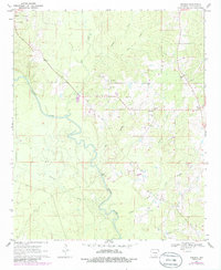
1970 Map of Herbine
USGS Topo · Published 1986About this map
The Saline River meanders through Cleveland County, anchoring a landscape defined by timbered bottomlands and rural crossroads. The small settlements of Herbine and Pansy serve as local focal points, surrounded by a network of creeks including Big Creek, Blakey Creek, and Double Mile Creek. Community life is anchored by landmarks like Free Hill Ch and the Prosperity Cem, while the regional topography is punctuated by Vince Bluff and an active Lookout Tower. This 1970s survey, updated with 1980s aerial data, documents a period of resource extraction as evidenced by numerous Gravel Pits scattered near the river, and the inclusion of a Roadside Park near Herbine reflecting the growth of local infrastructure during the late twentieth century.
Find a feature on this map
21 named features on this map. Tap any name to fly to it.
Don’t see what you’re looking for? This feature index may not catch every label — zoom into the map to look around manually.
Map Details
Editions of this 1970 Herbine Map
2 editions found
Other maps of this area

1935 · Feenyville
USGS Topo · 1:62,500

1953 · Greenwood
USGS Topo · 1:250,000

1953 · El Dorado
USGS Topo · 1:250,000

1956 · Greenwood
USGS Topo · 1:250,000

1957 · El Dorado
USGS Topo · 1:250,000

1958 · El Dorado
USGS Topo · 1:250,000

1960 · El Dorado
USGS Topo · 1:250,000
1970 · Calmer
USGS Topo · 1:24,000

1970 · New Edinburg
USGS Topo · 1:24,000

1970 · Herbine
USGS Topo · 1:24,000