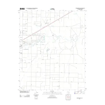
2012 Map of Hereford SE
USGS Topo · Published 2012About this map
Tierra Blanca Cr and the intermittent waters of Frio Draw carve through the High Plains landscape of Deaf Smith County in this 2012 survey. This area southeast of Hereford exhibits a distinct transition from the grid-patterned agricultural fields and cattle-related industries to the expanding infrastructure of the city’s periphery. The presence of Hereford Municipal Airport and the concentration of industrial markers like Industrial St, Dairy Rd, and Commerce St reflect the regional importance of agribusiness and transport in the Texas Panhandle. To the northeast, the small settlement of Joel sits along a primary corridor, while the man-made Leroy Johnson Lake provides a rare permanent water feature in this semi-arid environment. The extensive network of county roads, such as S Progressive Rd and Farm-To-Market Road 2943, illustrates the highly organized land use typical of this livestock-rich territory.
Find a feature on this map
45 named features on this map. Tap any name to fly to it.
Don’t see what you’re looking for? This feature index may not catch every label — zoom into the map to look around manually.
Map Details
Editions of this 2012 Hereford SE Map
This is the sole edition of this map. No revisions or reprints were ever made.
Other maps of this area

1954 · Clovis
USGS Topo · 1:250,000

1958 · Clovis
USGS Topo · 1:250,000

1961 · Buffalo Lake
USGS Topo · 1:62,500

1966 · Jumbo
USGS Topo · 1:24,000

1966 · Nazareth NW
USGS Topo · 1:24,000

1966 · Easter
USGS Topo · 1:24,000

1970 · Hereford
USGS Topo · 1:24,000

1971 · Hereford NE
USGS Topo · 1:24,000
1971 · Milo Center
USGS Topo · 1:24,000

1971 · Hereford SE
USGS Topo · 1:24,000