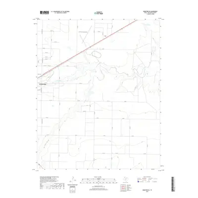
2019 Map of Hereford SE
USGS Topo · Published 2019About this map
The agricultural plains of Deaf Smith County unfold around the southeastern reaches of Hereford, where a grid of rural roads and watercourses defines the landscape. The Tierra Blanca Cr meanders across the center of the map, a vital drainage feature for the High Plains, while Frio Draw cuts through the southwestern corner. These ephemeral water systems are anchored by Leroy Johnson Lake in the northeast, providing a rare surface water landmark in this semi-arid region.
Find a feature on this map
35 named features on this map. Tap any name to fly to it.
Don’t see what you’re looking for? This feature index may not catch every label — zoom into the map to look around manually.
Map Details
Editions of this 2019 Hereford SE Map
This is the sole edition of this map. No revisions or reprints were ever made.
Other maps of this area

1954 · Clovis
USGS Topo · 1:250,000

1958 · Clovis
USGS Topo · 1:250,000

1961 · Buffalo Lake
USGS Topo · 1:62,500

1966 · Jumbo
USGS Topo · 1:24,000

1966 · Nazareth NW
USGS Topo · 1:24,000

1966 · Easter
USGS Topo · 1:24,000

1970 · Hereford
USGS Topo · 1:24,000

1971 · Hereford NE
USGS Topo · 1:24,000
1971 · Milo Center
USGS Topo · 1:24,000

1971 · Hereford SE
USGS Topo · 1:24,000