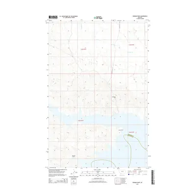
2014 Map of Herman Point
USGS Topo · Published 2014About this map
Fort Peck Lake dominates the southern portion of this landscape, its waters reaching into the coulees and draws that define the Garfield County shoreline. The rugged breaks of the Missouri River country are visible in the dense contour patterns surrounding Herman Point and Reynolds Hill. This 2014 survey documents the remote transition between the prairie uplands and the reservoir's edge, where drainage systems like Box Elder Cr and Johnny Cr carve through the sedimentary layers toward the water. A single significant terrestrial route, Fourchette Bay Rd, provides access through the northern sections, while the map also marks the political boundary where Phillips Co and Garfield Co meet within the lake's expansive reach. The landscape here is characterized by steep-walled features like Brandon Coulee, reflecting the erosive forces typical of the northern Montana badlands.
Find a feature on this map
13 named features on this map. Tap any name to fly to it.
Don’t see what you’re looking for? This feature index may not catch every label — zoom into the map to look around manually.
Map Details
Editions of this 2014 Herman Point Map
This is the sole edition of this map. No revisions or reprints were ever made.
Other maps of this area

1954 · Jordan
USGS Topo · 1:250,000

1956 · Jordan
USGS Topo · 1:250,000

1958 · Jordan
USGS Topo · 1:250,000

1964 · Jordan
USGS Topo · 1:250,000

1965 · Coal Mine Hill
USGS Topo · 1:24,000

1965 · Lost Creek
USGS Topo · 1:24,000

1965 · Sun Prairie
USGS Topo · 1:24,000

1965 · Herman Point
USGS Topo · 1:24,000

1965 · Pine Grove School
USGS Topo · 1:24,000
1965 · Mickey Butte
USGS Topo · 1:24,000