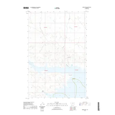
2020 Map of Herman Point
USGS Topo · Published 2020About this map
Fort Peck Lake dominates this landscape on the border of Phillips and Garfield counties. This 2020 survey illustrates the complex shoreline of the reservoir, where fingers of water reach into landforms such as Brandon Coulee and Skibby Bottom. To the north, the terrain rises toward Reynolds Hill and the namesake Herman Point, providing a clear view of the topographical relief between the high ridges and the water's edge. Access to these remote overlooks is provided by a thin network of unimproved routes, including Reynolds Rd and Reynolds Hill Rd. Several drainages, such as Box Elder Cr and Johnny Cr, trace the natural hydrology of the area as they flow toward the massive impoundment of the Missouri River.
Find a feature on this map
14 named features on this map. Tap any name to fly to it.
Don’t see what you’re looking for? This feature index may not catch every label — zoom into the map to look around manually.
Map Details
Editions of this 2020 Herman Point Map
This is the sole edition of this map. No revisions or reprints were ever made.
Other maps of this area

1954 · Jordan
USGS Topo · 1:250,000

1956 · Jordan
USGS Topo · 1:250,000

1958 · Jordan
USGS Topo · 1:250,000

1964 · Jordan
USGS Topo · 1:250,000

1965 · Coal Mine Hill
USGS Topo · 1:24,000

1965 · Lost Creek
USGS Topo · 1:24,000

1965 · Sun Prairie
USGS Topo · 1:24,000

1965 · Herman Point
USGS Topo · 1:24,000

1965 · Pine Grove School
USGS Topo · 1:24,000
1965 · Mickey Butte
USGS Topo · 1:24,000