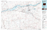
1984 Map of Hermiston
USGS Topo · Published 1984About this map
The Ordnance Depot dominates the central landscape of this mid-1980s Umatilla County survey, reflecting the area's significant military and logistical footprint. Positioned between the Columbia River and the high desert plains, the region is a complex intersection of irrigated agriculture and heavy transport. The growth of Hermiston and Stanfield is shown alongside established transportation corridors, including the Union Pacific and Burlington Northern railroads that parallel the river's south bank.
Find a feature on this map
67 named features on this map. Tap any name to fly to it.
Don’t see what you’re looking for? This feature index may not catch every label — zoom into the map to look around manually.
Map Details
Editions of this 1984 Hermiston Map
2 editions found
Other maps of this area

1906 · Blalock Island
USGS Topo · 1:125,000

1908 · Blalock Island
USGS Topo · 1:125,000

1908 · Umatilla
USGS Topo · 1:125,000

1910 · Zillah
USGS Topo · 1:125,000

1915 · Wallulah
USGS Topo · 1:96,000

1915 · Prosser
USGS Topo · 1:125,000

1916 · Arlington
USGS Topo · 1:125,000

1916 · Condon
USGS Topo · 1:125,000

1917 · Pasco
USGS Topo · 1:125,000

1917 · Prosser
USGS Topo · 1:125,000