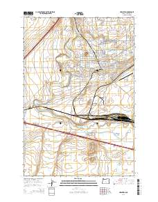
2014 Map of Hermiston
USGS Topo · Published 2014About this map
Hermiston serves as the focal point of this Eastern Oregon study, highlighting a landscape defined by an intricate network of irrigation infrastructure and heavy rail transport. The northern portion of the map is dominated by the city's residential and civic grid, including the Umatilla County Fairgrounds and Hermiston Rodeo Grounds. South of the city, the Union Pacific rail lines converge at the major yard at Hinkle, a critical junction for the region's agricultural economy. This 2014 survey documents how water management transformed the high desert, with numerous waterways like the Westland A Canal, Maxwell Canal, and Feed Canal lacing through the terrain around the Umatilla River. Prominent geographical features such as Hermiston Butte and Cottonwood Bend provide natural landmarks amidst the developing outskirts and rural clusters of Bucks Corners and Umatilla Meadows.
Find a feature on this map
119 named features on this map. Tap any name to fly to it.
Don’t see what you’re looking for? This feature index may not catch every label — zoom into the map to look around manually.
Map Details
Editions of this 2014 Hermiston Map
This is the sole edition of this map. No revisions or reprints were ever made.
Other maps of this area

1908 · Umatilla
USGS Topo · 1:125,000

1953 · Pendleton
USGS Topo · 1:250,000

1956 · Pendleton
USGS Topo · 1:250,000

1962 · Hat Rock
USGS Topo · 1:24,000

1962 · Stanfield
USGS Topo · 1:24,000

1962 · Ordnance
USGS Topo · 1:24,000

1962 · Hermiston
USGS Topo · 1:24,000
1962 · Irrigon
USGS Topo · 1:24,000

1962 · Umatilla
USGS Topo · 1:24,000

1968 · Service Buttes NW
USGS Topo · 1:24,000