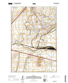
2020 Map of Hermiston
USGS Topo · Published 2020About this map
The Hermiston city center and its surrounding agricultural landscape are defined by an intricate network of irrigation systems and rail infrastructure. Modern development radiates from the core, bounded by the Union Pacific RR yards at Hinkle and the high ground of Hermiston Butte. The Umatilla River meanders across the center of the sheet, supplemented by a complex grid of man-made waterways including the Maxwell Canal, A Line Canal, and the Hermiston Ditch.
Find a feature on this map
180 named features on this map. Tap any name to fly to it.
Don’t see what you’re looking for? This feature index may not catch every label — zoom into the map to look around manually.
Map Details
Editions of this 2020 Hermiston Map
This is the sole edition of this map. No revisions or reprints were ever made.
Other maps of this area

1908 · Umatilla
USGS Topo · 1:125,000

1953 · Pendleton
USGS Topo · 1:250,000

1956 · Pendleton
USGS Topo · 1:250,000

1962 · Hat Rock
USGS Topo · 1:24,000

1962 · Stanfield
USGS Topo · 1:24,000

1962 · Ordnance
USGS Topo · 1:24,000

1962 · Hermiston
USGS Topo · 1:24,000
1962 · Irrigon
USGS Topo · 1:24,000

1962 · Umatilla
USGS Topo · 1:24,000

1968 · Service Buttes NW
USGS Topo · 1:24,000