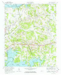
1968 Map of Hermitage
USGS Topo · Published 1970About this map
The Hermitage Tomb serves as a major cultural anchor on this mid-century landscape, marking the historic estate of Andrew Jackson just north of the growing settlement at Hermitage. The terrain is defined by the massive water bodies of Old Hickory Lake on the Cumberland River to the north and the sprawling J Percy Priest Reservoir to the south. This era shows the suburbanization of Davidson County as residential areas like Lakewood and Hopewell expand near the Louisville and Nashville railroad tracks.
Find a feature on this map
53 named features on this map. Tap any name to fly to it.
Don’t see what you’re looking for? This feature index may not catch every label — zoom into the map to look around manually.
Map Details
Editions of this 1968 Hermitage Map
3 editions found
Other maps of this area

1903 · Nashville
USGS Topo · 1:125,000

1932 · Hermitage
USGS Topo · 1:62,500

1942 · Gallatin
USGS Topo · 1:100,000

1942 · Lebanon
USGS Topo · 1:100,000

1951 · Martha
USGS Topo · 1:24,000

1952 · Goodlettsville
USGS Topo · 1:24,000

1952 · Hendersonville
USGS Topo · 1:24,000

1952 · Hermitage
USGS Topo · 1:24,000

1952 · La Vergne
USGS Topo · 1:24,000

1952 · Nashville East
USGS Topo · 1:24,000