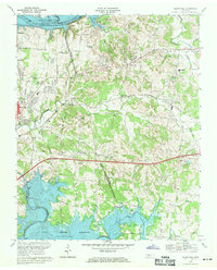
1968 Map of Hermitage
USGS Topo · Published 1971About this map
The Hermitage Tomb and the surrounding grounds of the Andrew Jackson estate anchor the western portion of this 1968 landscape, situated just east of the Nashville city limits. The terrain transitions from the developed suburbs of Lakewood and Hopewell toward the growing community of Mount Juliet in the east. This period captures the region's mid-century expansion, evidenced by a dense network of schools like Andrew Jackson Sch and Dodson Sch, alongside numerous spiritual centers such as Lebanon Road Ch and New Hope Ch.
Find a feature on this map
49 named features on this map. Tap any name to fly to it.
Don’t see what you’re looking for? This feature index may not catch every label — zoom into the map to look around manually.
Map Details
Editions of this 1968 Hermitage Map
3 editions found
Other maps of this area

1903 · Nashville
USGS Topo · 1:125,000

1932 · Hermitage
USGS Topo · 1:62,500

1942 · Gallatin
USGS Topo · 1:100,000

1942 · Lebanon
USGS Topo · 1:100,000

1951 · Martha
USGS Topo · 1:24,000

1952 · Goodlettsville
USGS Topo · 1:24,000

1952 · Hendersonville
USGS Topo · 1:24,000

1952 · Hermitage
USGS Topo · 1:24,000

1952 · La Vergne
USGS Topo · 1:24,000

1952 · Nashville East
USGS Topo · 1:24,000