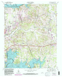
1968 Map of Hermitage
USGS Topo · Published 1983About this map
The Hermitage Tomb serves as the focal point for this region east of Nashville, where the legacy of Andrew Jackson's estate meets mid-century suburban expansion. The landscape is defined by the heavy presence of the Old Hickory Lake and Percy Priest Reservoir systems, which transformed the Stones River and Cumberland River basins into expansive public use areas. The map reveals a transition from traditional agricultural settlements like Mount Juliet and Hopewell to a more developed residential pattern, including the Lakewood and Green Hill communities.
Find a feature on this map
56 named features on this map. Tap any name to fly to it.
Don’t see what you’re looking for? This feature index may not catch every label — zoom into the map to look around manually.
Map Details
Editions of this 1968 Hermitage Map
3 editions found
Other maps of this area

1903 · Nashville
USGS Topo · 1:125,000

1932 · Hermitage
USGS Topo · 1:62,500

1942 · Gallatin
USGS Topo · 1:100,000

1942 · Lebanon
USGS Topo · 1:100,000

1951 · Martha
USGS Topo · 1:24,000

1952 · Goodlettsville
USGS Topo · 1:24,000

1952 · Hendersonville
USGS Topo · 1:24,000

1952 · Hermitage
USGS Topo · 1:24,000

1952 · La Vergne
USGS Topo · 1:24,000

1952 · Nashville East
USGS Topo · 1:24,000