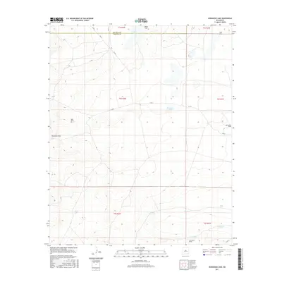
2017 Map of Hernandez Lake
USGS Topo · Published 2017About this map
The arid landscape along the border of De Baca and Chaves Counties is defined by its vital water management features, serving a region shaped by ranching and resource management. The geography is dominated by numerous draws and ephemeral basins, including Hernandez Draw and Salt Draw, which channel seasonal runoff through this high desert environment. Notable landmarks such as Hernandez Lake and Salt Lake provide focal points in the terrain, while the map reveals a extensive network of named stock tanks and depressions. These features, including Grandpa Tank, Windy Smith Tank, and McDowell Tank, indicate the historic reliance on collected water for livestock in the late 20th and early 21st centuries. The presence of Van Eaton Draw and White Draw further illustrates the complex drainage patterns of the area, while local routes like Olive RD and Co RD 4 provide the few reliable paths through this sparsely settled corner of New Mexico.
Find a feature on this map
26 named features on this map. Tap any name to fly to it.
Don’t see what you’re looking for? This feature index may not catch every label — zoom into the map to look around manually.
Map Details
Editions of this 2017 Hernandez Lake Map
This is the sole edition of this map. No revisions or reprints were ever made.
Other maps of this area

1954 · Fort Sumner
USGS Topo · 1:250,000

1955 · Roswell
USGS Topo · 1:250,000

1958 · Fort Sumner
USGS Topo · 1:250,000

1958 · Roswell
USGS Topo · 1:250,000

1962 · Roswell
USGS Topo · 1:250,000

1967 · Deering Place
USGS Topo · 1:24,000

1967 · Cottonwood Draw
USGS Topo · 1:24,000

1967 · Hernandez Lake
USGS Topo · 1:24,000
1967 · Haystack Butte
USGS Topo · 1:24,000
1967 · La Espia Peak
USGS Topo · 1:24,000