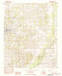
1982 Map of Hernando
USGS Topo · Published 1982About this map
The county seat of Hernando serves as the focal point for this survey of the northern Mississippi landscape, just before the suburban expansion of the late twentieth century. Located at the intersection of local transport routes and regional drainage, the town's grid is bounded by a network of waterways that define the local topography. To the south, the terrain descends toward the vast waters of Arkabutla Lake, a major flood control feature fed by the Coldwater River. This water-rich environment is intricately detailed with seasonal drainages such as Mussacuna Creek and Short Fork, which carve through the land between smaller settlements like Bright and Love. The proximity of the De Soto and Tate County line highlights the regional importance of the area's hydraulic systems, showing how the river and its tributaries dictated the placement of roads and the extent of early development across this portion of the Magnolia State.
Find a feature on this map
14 named features on this map. Tap any name to fly to it.
Don’t see what you’re looking for? This feature index may not catch every label — zoom into the map to look around manually.
Map Details
Editions of this 1982 Hernando Map
2 editions found
Other maps of this area

1932 · Horn Lake
USGS Topo · 1:48,000

1932 · Crenshaw
USGS Topo · 1:62,500

1935 · Crenshaw
USGS Topo · 1:62,500

1935 · Horn Lake
USGS Topo · 1:62,500

1944 · Senatobia
USGS Topo · 1:62,500

1944 · Hernando
USGS Topo · 1:62,500

1948 · Helena
USGS Topo · 1:250,000

1950 · Helena
USGS Topo · 1:250,000

1955 · Helena
USGS Topo · 1:250,000

1956 · Tupelo
USGS Topo · 1:250,000