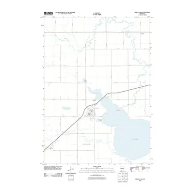
2010 Map of Heron Lake
USGS Topo · Published 2010About this map
Heron Lake and its intricate drainage network define this corner of Jackson County, where the Heron Lake Outlet Dam regulates the transition from the lake into the Heron Lake Outlet. The landscape is etched with the geometric precision of the public land survey system, evidenced by numerous numbered thoroughfares like 400th Ave and 910th St. Local history is anchored at the Heron Lake Post Office, while the surrounding agricultural lands are dotted with significant sites for genealogical research, including Lakeside Cemetery, Sacred Heart Cemetery, and Springfield Cemetery. To the southwest, the small settlement of Miloma sits near the crossing of Jack Creek, which meanders toward the larger lake body. The presence of Judicial Ditch Number Two and the Des Moines River in the northwest illustrates the region's managed water systems and natural riparian corridors.
Find a feature on this map
30 named features on this map. Tap any name to fly to it.
Don’t see what you’re looking for? This feature index may not catch every label — zoom into the map to look around manually.
Map Details
Editions of this 2010 Heron Lake Map
This is the sole edition of this map. No revisions or reprints were ever made.
Other maps of this area

1954 · Fairmont
USGS Topo · 1:250,000

1958 · Fairmont
USGS Topo · 1:250,000

1960 · Brewster
USGS Topo · 1:24,000

1960 · Okabena
USGS Topo · 1:24,000

1970 · Heron Lake NW
USGS Topo · 1:24,000
1970 · Harder Lake
USGS Topo · 1:24,000

1970 · Dundee
USGS Topo · 1:24,000

1970 · Wilder
USGS Topo · 1:24,000

1970 · Lakefield
USGS Topo · 1:24,000
1970 · Heron Lake NE
USGS Topo · 1:24,000